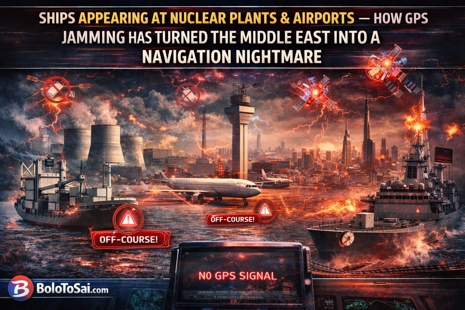
STRAIT OF HORMUZ/WASHINGTON/DUBAI — Imagine your ship’s navigation system telling you that you are parked at a nuclear power plant — when you are actually sailing in the middle of the Persian Gulf. This is not science fiction. This is the terrifying reality facing over 1,100 vessels in the Middle East right now, as the Iran-Israel-USA war has unleashed the most intense GPS jamming and spoofing campaign in maritime history. BoloToSai breaks down what is happening, why it is happening, and what it means for the world.
ANALYTICAL BRIEF — GPS CRISIS STATUS (8 MARCH 2026)
| Parameter | Details |
|---|---|
| Vessels Affected | 1,100+ in 24 hours — 655 total logged by Lloyd’s List |
| Total GPS Interference Events | 1,735 — Lloyd’s List Intelligence |
| Daily Incidents | Doubled — from 350 to 672 between Feb 28 & March 2 |
| New Jamming Clusters | 21 identified — UAE, Qatar, Oman, Iran waters |
| Aircraft Affected | 169 planes over Arabian Peninsula — March 2 alone |
| Ships Appearing At | Nuclear power plant, airports, Iranian land |
| Strait of Hormuz Traffic | Near complete halt |
| Iran’s Navigation Switch | GPS abandoned — switched to China’s BeiDou system |
| Previous Tanker Collision | Adalynn & Front Eagle — June 2025, UAE coast |
| Countries GPS Affected | UAE, Saudi Arabia, Oman, Qatar, Kuwait, Bahrain, Lebanon |
WHAT IS HAPPENING — THE SIMPLE EXPLANATION
The global positioning system capabilities of cargo ships, oil tankers and other vessels stuck in the Middle East because of the widening war are likely worse than those in your cell phone. This deficiency explains why since the start of US-Israeli strikes, thousands of ships have found themselves unable to determine their real location.
There are two distinct weapons being used:
GPS Jamming: Jamming a GPS signal is “not that complicated.” All one needs is “another radio transmitter that can broadcast on the same frequency, but louder” — which creates “a wall of mush.” In other words, militaries simply drown out the real GPS signal with noise — leaving ships blind.
GPS Spoofing: Spoofing is far more sinister. Spoofing manipulates a ship’s Automatic Identification System, causing the affected ship to send a fake or even nonsensical location — meaning ships could appear to be on land in Iran or the Emirates. Every vessel transmits its identity, destination and position every second over a universal radio frequency. Spoofing hijacks that transmission and replaces it with a completely false location.
THE SHOCKING SCENES IN THE GULF
Ships were falsely positioned at airports, a nuclear power plant, and on Iranian land — creating navigation and compliance risks across UAE, Qatari, Omani and Iranian waters. Maritime tracking maps showed vessels appearing to sail in perfect geometric “crop circles” — a classic telltale sign of GPS manipulation. On March 2 alone, at least 169 planes flying over the eastern part of the Arabian Peninsula were hit by spoofing. Within 24 hours of the first US-Israeli strikes on Iran, ships in the region’s waters found their navigation systems had gone haywire — erroneously indicating that vessels were at airports, a nuclear power plant and on Iranian land. The consequences are deadly serious. Spoofing can trick a ship into believing it is in safe water when it is actually drifting toward land or into the territorial waters of a hostile state.
WHY ARE SHIPS’ GPS SYSTEMS SO VULNERABLE?
Unlike smartphones, which use multiple frequencies and satellite networks, ships’ navigation systems are relatively basic — leaving them vulnerable to signal interference. Your mobile phone can switch between GPS, Galileo, GLONASS and BeiDou satellite networks. Most commercial ships cannot. Most ships are unable to rely on the BeiDou or Galileo systems in the event that GPS is jammed. The situation is even worse for airplanes due to aviation regulations — no aircraft flying in the world today has a built-in GPS receiver capable of tracking signals other than GPS L1 C/A — technology that is out of date by 15 years. Today, GPS signals are not just used to determine location — they also power onboard clocks, radar systems and speed logs. When GPS goes down, an entire cascade of ship systems begins to fail simultaneously.
WHO IS DOING THE JAMMING?
All sides in this conflict are deploying GPS warfare. Used by all sides in conflict zones to disrupt the paths of drones and missiles, the process involves militaries and affiliated groups intentionally broadcasting high-intensity radio signals in the same frequency bands used by navigation tools. Gulf states are directing their jamming systems towards their own shores to ward off Iran’s satellite-guided Shahed drones — at the cost, deemed acceptable, of disrupting civilian navigation. Iran is simultaneously deploying its military-grade Murmansk-BN jamming system — capable of covering a radius of hundreds of kilometres — creating vast GPS-denied zones across the Gulf.
This is not a new tactic. Interference has been a major issue for shipping and aircraft since the Russian invasion of Ukraine in 2022, when drones were widely deployed in combat for the first time. But the scale seen in the Middle East right now is completely unprecedented.
IRAN’S MASTERSTROKE — SWITCHING TO CHINA’S BEIDOU
In perhaps the most strategically significant development of the entire GPS crisis, Iran quietly completed the most consequential satellite navigation switch in recent history — abandoning the US GPS system entirely and switching to China’s BeiDou navigation system. BeiDou was designed from inception to function under contested, degraded and adversarial electromagnetic conditions. China built in stronger signal authentication, signal diversity across multiple frequencies, and an encrypted precision positioning service unavailable to adversaries — making spoofing and jamming significantly harder than GPS. The geopolitical implication is enormous — Iran has essentially removed itself from US and Israeli GPS infrastructure dependence. Any military playbook that assumed GPS disruption as a tool against Iran now needs to be completely rewritten.
THE HUMAN COST — SHIPS NAVIGATING BLIND
The jamming and spoofing forced some tankers to reverse course or go dark — a state in which signals from a vessel’s Automatic Identification System are no longer broadcast or detected. Given the size of the ships, electronic assistance has become necessary to steer them. Crews must resort to using 20th century instruments — radar or visible landmarks. Younger mariners, trained entirely on digital GPS systems, are often completely unfamiliar with these older techniques.
In June 2025, electronic interference with navigation systems was thought to be a factor in the collision between two oil tankers — Adalynn and Front Eagle — off the coast of the UAE. With GPS interference now at historically unprecedented levels, the risk of catastrophic maritime collisions in one of the world’s most congested shipping lanes has never been higher.
WHAT COMES NEXT — IS THERE A SOLUTION?
Solutions do exist — such as enhancing receivers with anti-spoofing features and encryption, or installing antennas specifically designed to protect against jamming and spoofing — but upgrading and replacing existing systems takes time and money. CNN Start-ups are developing alternative technologies using Earth’s magnetic field or quantum inertial navigation — but these remain far from widespread operational use. Al Jazeera The Royal Institute of Navigation’s director Ramsey Faragher delivered the most sobering assessment of all: “GNSS is a wonder of the modern world. You can switch it on and within a few seconds it works out where you are to within a meter and what time it is to within a nanosecond. Unfortunately, the luxurious era of those signals not being messed about with intentionally is over. We need to rapidly catch up.” CNN
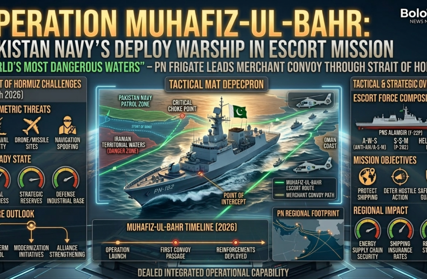
WHAT THIS MEANS FOR PAKISTAN
Pakistan’s trade lifeline runs directly through the affected waters. Hundreds of Pakistani cargo vessels and oil tankers transit the Persian Gulf and Strait of Hormuz every month. With GPS jamming now endemic across these waters and the Strait of Hormuz at a near standstill, Pakistan faces:
Trade disruption: Cargo ships carrying Pakistani exports and imports are navigating blind — increasing delivery times, insurance costs and the risk of accidents.
Energy supply threat: Oil tankers supplying Pakistan’s fuel needs are either anchored, reversing course or going dark — directly threatening the fuel supply chain that is already under pressure from the Rs.55 per litre price hike announced this week.
Insurance crisis: Marine insurers have begun dropping coverage for vessels in the Gulf — making it harder and more expensive for Pakistani shipping companies to operate in the region.
BOLOTSAI ASSESSMENT
The GPS crisis in the Middle East is not a side story of the Iran-Israel-USA war — it is one of its most consequential chapters. Over 1,100 ships navigating blind. Aircraft systems failing. Ships appearing at nuclear plants on tracking screens. Iran switching to an unjammable Chinese satellite system. The world’s most critical oil shipping lane at a near standstill.
GPS is being weaponized by states, and its reliability as a global infrastructure is degrading. Th sundayguardianlivee Iran-Israel-USA war has not just set the Middle East on fire — it has revealed a catastrophic vulnerability at the heart of the global navigation system that the entire modern world depends upon.
The era of reliable GPS is over. The question now is — what comes next?
Sources: CNN, France 24, Al-Monitor, Windward Maritime AI, Lloyd’s List Intelligence, AFP, The National | All figures verified at time of publishing — 8 March 2026
#GPSJamming #GPSSpoofing #StraitOfHormuz #IranIsraelWar #MaritimeCrisis #BoloToSai #BreakingNews

 By
By

 By
By